Nos randonnées

En cliquant sur l’image vous ferez apparaître nos randonnées avec:
- le plan téléchargeable en pdf
- la possibilité de télécharger le fichier GPX pour votre GPS
- le lien pour le retrouver sur le site de Wikiloc (soumis à abonnement)
Listing des randonnées (mise à jour JN du 25-08-2026)
33- Les hauts de Berre (Pipriac)
Fichier GPX pour votre GPS:
Lien WIKILOC:
https://loc.wiki/t/120226238?wa=sc
32- Etang des 4 vents (Pipriac) 8,5 Km
Fichier GPX pour votre GPS:
Lien WIKILOC:
https://loc.wiki/t/138535711?wa=sc
31- L’île aux pies (Bain sur Oust) 10,7 Km
Fichier GPX pour votre GPS:
Lien WIKILOC:
https://loc.wiki/t/134931453?wa=sc
30- BOEUVRES (Guipry-Messac) 9 Km
Fichier GPX pour votre GPS:
Lien WIKILOC:
https://loc.wiki/t/117341245?wa=sc
29- BESLE 7,6 Km 03-10-2023
Fichier GPX pour votre GPS
Lien WIKILOC:
https://loc.wiki/t/149042890?wa=sc
28- Langon 8,79 km 10.03.2026
Fichier GPX pour votre GPS:
Lien Wikiloc:
https://loc.wiki/t/253816257?wa=sc
27- Saint JUST le début du ruisseau via le bourg 7,88 km
Fichier GPX pour le GPS:
Lien WIKILOC:
https://loc.wiki/t/247533765?wa=sc
26- Saint Ganton (bis) du 09-12-2025 9,6 km
Fichier GPX pour votre GPS:
Lien WIKILOC:
https://loc.wiki/t/243190411?wa=sc
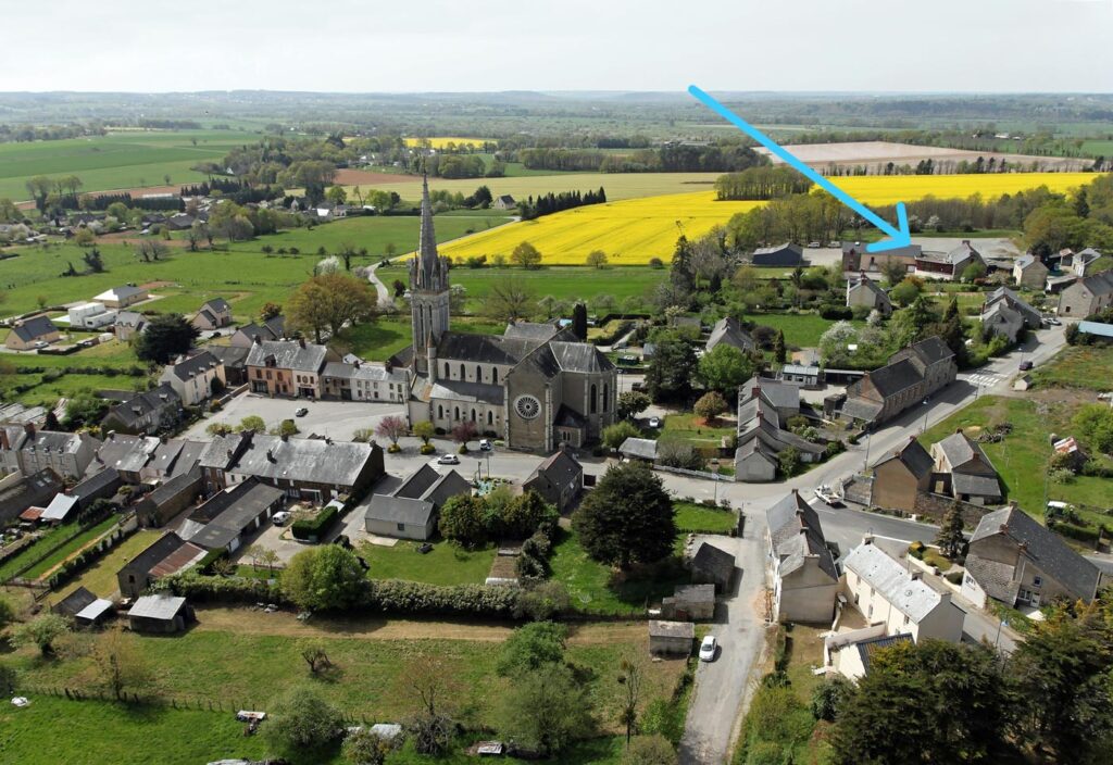
25- Marais et rivières de Gannedel à la Chapelle de Brain
A compter de 2026 le départ de la rando aura lieu depuis le parking de la salle polyvalente à la Chapelle de Brain ( plus de commodités pour le stationnement des véhicules).
Situé à la pointe de la flèche bleue
Fichier GPX pour votre GPS:
Lien WIKILOC:
https://loc.wiki/t/187386925?wa=sc
24- Quelneuc 14-10-22 8,35km
Fichier GPX pour votre GPS:
Lien WIKILOC:
https://fr.wikiloc.com/itineraires-randonnee/queleuc-153804113
23- Redon 21-01-2025
Fichier GPX pour votre GPS:
Lien WIKILOC:
https://fr.wikiloc.com/itineraires-randonnee/redon-21-01-25-198783698
22- Sixt sur Aff – La Chapelle Gaceline 10,98km 03-12-2024
Fichier GPX pour votre GPS:
Lien Wikiloc:
21- Sainte Marie circuit des ardoisière 9,21km 12-10-24
Fichier GPX pour votre GPS
Lien WIKILOC:
https://fr.wikiloc.com/itineraires-randonnee/les-ardoisieres-9-21-km-12-10-24-187991188
20- Pipriac – Traversot 7 km du 20-06-2024
Fichier GPX pour votre GPS:
Lien WIKILOC:
https://fr.wikiloc.com/itineraires-randonnee/pipriac-traversot-20-06-24-174788983
19- LANGON Bord de vilaine 9km du 14-05-2024
Fichier GPX pour votre GPS:
Lien WIKILOC:
https://fr.wikiloc.com/itineraires-randonnee/langon-bord-de-vilaine-14-05-2024-9km-170737930
18- MERNEL Le bois Boutin 8km
Circuit très facile, pas de dénivellé, peu de route bitumée, les visibilités pour traverser la D 69 sont bonnes.
Fichier GPX pour votre GPS:
Lien Wikiloc:
https://fr.wikiloc.com/itineraires-randonnee/mernel-8-km-164657465
17- Saint Just Les fées de Tréal 10km
Fichier GPX pour votre GPS:
Lien Wikiloc:
https://fr.wikiloc.com/itineraires-randonnee/st-just-les-fees-de-treal-164391990
16- Circuit de « La Gacilly – Graslia » 9,81 km du 20-02-2024
Fichier GPX pour votre GPS:
Lien Wikiloc:
https://fr.wikiloc.com/itineraires-randonnee/la-gacilly-graslia-9-84-km-du-20-02-24-161755625
15- Circuit de « Le Meneu » à Pipriac 9,6 KM DU 23-01-2024
Fichier GPX pour votre GPS:
Lien Wikiloc:
https://fr.wikiloc.com/itineraires-randonnee/le-meneu-23-01-2024-9-44km-158931854
14-
Fichier GPX pour votre GPS
Lien Wikiloc:
13- Baron circuit 7,68km du 30-05-2023


Fichier GPX pour GPS
Lien Wikiloc:
https://fr.wikiloc.com/itineraires-randonnee/baron-circuit-du-30-05-2023-7-68km-136235542
12- Bois de Beaucel – Saint Ganton 10,23km du 23-05-2023
Fichier GPX pour le GPS
Lien Wikiloc:
11- Redon-Bahurel du 06-05-2023 de 7,14 km

Fichier GPX pour GPS:
Lien Wikiloc:
https://fr.wikiloc.com/itineraires-randonnee/redon-bahurel-06-05-2023-134259282
10- Circuit du ruisseau à Saint Just (journée interclub du 27-04-23) 5,8Km
Fichier GPX pour GPS:
Lien Wikiloc:
9- Circuit de chaumeray 11,06 km du 02-05-2023
(Circuit situé au Nord de Guipry-Messac et au Nord/Est de Lohéac)


Fichier GPX pour GPS
Lien Wikiloc:
https://fr.wikiloc.com/itineraires-randonnee/chaumeray-11-06km-le-02-05-23-133556357
8- La Gacilly circuit des collines (éoliennes) 10,5 Km
Fichier GPX pour GPS:
Lien Wikiloc:
https://loc.wiki/t/120705831?wa=sc
7- Les Ardoisière Sainte marie variante 12,73km
Fichier GPX pour GPS:
Lien WIKILOC:
https://fr.wikiloc.com/itineraires-randonnee/les-ardoisieres-ste-marie-variante-12-73km-128997202
6- Circuit : Carentoir 13km du 07-03-23
Télécharger le fichier pour GPS:
Lien Wikiloc
https://fr.wikiloc.com/itineraires-randonnee/carentoir-13km-du-07-03-23-127679195
5- Circuit : Les Brulais Comblessac 8,1km du 27-01-23
Lien vers wikiloc:
https://fr.wikiloc.com/itineraires-randonnee/les-brulais-comblessac-81-km-du-27-01-2023-124359010
4- Cournon – Circuit du dolmen
Lien vers Wikiloc:
https://fr.wikiloc.com/itineraires-randonnee/cournon-9-9km-le-20-01-23-123816296
3- Bruc sur Aff
lien vers Wikiloc:
https://fr.wikiloc.com/itineraires-randonnee/bruce-sur-aff-petite-123095136
2- Les hauts de Sixt sur Aff
Lien vers Wikiloc:
https://fr.wikiloc.com/itineraires-randonnee/les-haut-de-sixt-sur-aff-8-6km-du-18-11-2022-119422977
1- Saint Just Mégalithes et vieux bourg
Lien vers Wikiloc:
https://fr.wikiloc.com/itineraires-randonnee/st-just-04-10-22-9-2km-115321063